High-resolution remote sensing satellites
 0 Comment(s)
 Print
Print E-mail CNTV, December 28, 2016


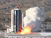
China has launched a pair of high-resolution, remote sensing satellites from the Taiyuan Satellite Launch Center in Shanxi Province. The satellites, named SuperView, blasted off on the back of a Long March 2D rocket.
 |
|
A Long March 2D rocket carrying a pair of 0.5-meter high-resolution remote sensing satellites, SuperView-1 01/02, blasts off from the launch pad at the Taiyuan Satellite Launch Center in north China's Shanxi Province, Dec. 28, 2016. The satellites are able to provide commercial images at 0.5-meter resolution. [Photo/Xinhua] |
They can provide commercial images with a 0.5-meter resolution for land resources survey, mapping, environmental monitoring, and financial insurance. A science satellite created by students was also put into orbit for the first time. The project is to encourage interest in space technology among the young.


