Qinghai's
Meteorological Bureau has announced that water inflow to the upper
reaches of the country's second longest river has continued to
shrink since the 1990s due to dry and warm weather thought to be
caused by global warming.
The statement was made at a meeting on Yellow River control and
management over the weekend in Zhengzhou, capital of Henan
Province.
The bureau said that average runoff reached 375 cubic meters per
second in 2002, only 58 percent of the average volume in past
decades.
Rainfall, the main source of water for the river's upper
reaches, has fallen sharply in recent years.
At the same time, evaporation in rivers across the country is
expected to increase by 15 percent, said Ding Yihui, an expert from
China Meteorological
Administration.
Ding said global warming, caused by excessive discharge of
greenhouse gases through overuse of energy, could reduce crop
outputs across the country by 5 to 10 percent in 2030, according to
the official Xinhua News Agency.
Water shortages in the Yellow River have already slashed crop
outputs along the river basin's grain production provinces such as
Henan and Shandong.
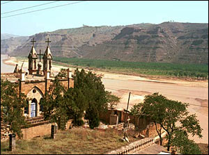
Beside declines in the water level, the Yellow River also faces
other challenges including shrinking watercourses in its lower
reaches and higher levels of silt, said experts.
Sediment on the river bed in Shandong and Henan provinces has
filled in many watercourses, threatening the safety of the 1.8
million people who live on flood plains along the lower reaches,
said Chen Lei, vice minister of water resources.
The river now carries some 1.6 billion tons of silt annually with a
quarter of this deposited on the riverbed downstream, water experts
said.
The river bed in the lower reaches was up to 10 meters higher
than surrounding fields in the Henan and Shandong sections, leading
to the Yellow River being described as a "hanging river."
The Yellow River used to be notorious for regularly bursting it
banks and changing course every century or so.
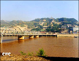
The 5,464-kilometer-long river originates on the Qinghai-Tibet
Plateau and winds its way through eight provinces and regions
before emptying into the Bohai Sea.
(China Daily November 16, 2004)